Over the past few days the news has been dominated by problems caused by the floods. We have had our screens filled with people suffering and trying to make sense of what has happened. Some have wanted someone to blame, anyone and they have been given much air time to vent their frustrations. The news media has also paid uncritical attention to any one with a pet theory as to how these things could have been avoided. The final icing on the cake was on Sunday when Eric Pickles tried to blame the ‘ so called experts ‘ for giving ministers wrong advice. This resulted in a very ugly spat between all the agencies involved which helped no one. By yesterday we had government spin going into overdrive with everyone from the Prime Minister down spouting, sorry about the pun, the same line “…now is not the time…people should concentrate on their jobs…plenty of time once this whole situation has been resolved to identify mistakes…”
Several years ago I was given the task to prepare the contingency plans for vital buildings throughout north Leicestershire in case of evacuation due to disaster. The most likely scenario I had to look at was flooding. As soon as I did this I realised just how powerful flooding can be and also how many more properties are exposed to flooding than is commonly known. The first step in trying to assess the problem was to visit the Environmental Agencies Flood Map for Planning website. Many modern towns have buried rivers running through that few people know about until it floods. This gave me a real understanding of the problem of flooding and how it could effect many people.
The media has been full of angry residents from communities badly effected by the floods. The first was around Moorland and Burrowbridge on the Somerset Levels. So I checked the Flood Map for the area and it made very depressing viewing: 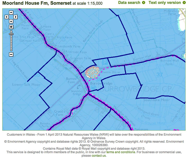 The map paints a painful picture for anyone who lives at Burrowbridge – expect flooding. Most of the land around Burrowbridgee is no more than 4 metres above sea level. What this means is that there is no where for the excess water to go as water has to flow down hill and as it is almost sea level then it can’t. Also some of the place names indicate that in the past the area was a salt marsh as there are old salt workings – in fact they go back to the Bronze Age. This again indicates that the area was once inundated with sea water to such an extent that salt could be extracted from it. The question of dredging has been raised and whilst I suspect it might help during the early phases of the flood to get water to the sea as more water arrives it would have no decreeable effect at all as the water has no where to flow.
Burrowbridge and the Somerset levels have now been replaced in the media spotlight by Wraysbury, outside Windsor and just to the west of London. Many frustrated and angry members of the public have been only too happy to tell their stories to the media about their plight and fears. All of this is understandable but examination of the Flood Map tells its own story:
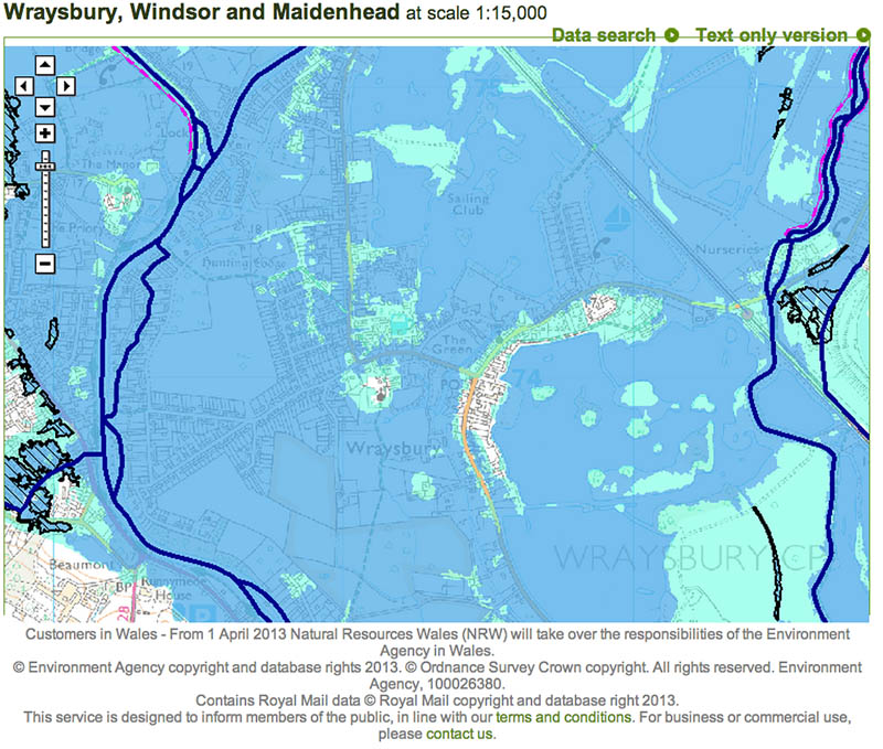
Wraybury is situated on the flood plain between the River Thames and the smaller Colne Brook. The low flat land has a series of pools which were probably gravel workings from the past. Very little of the village is immune to flooding and in fact is next to Runnymede where the Magna Carta was negotiated and signed. The reason why this is important is that it was seen as a land in the middle of the river and so neutral to all sides. So in short this land was always going to flood under normal conditions let alone the exceptional ones we are facing now.
That, I guess, is my biggest critisim of the government. They have not been very good at getting this point over. In fact they seem to have tried to pander to every person with an idea of how to fix this problem rather than sticking to the realities on the ground. These areas are prone to flooding under normal conditions – these are not and we should do as much as is possible to help the people suffering. This is the message that is starting to come out from central government but only belatedly after the train wreak that was Eric Pickles on Sunday.
I have the greatest sympathy with the people effected by the flooding. I live above a flood plain and so am very aware how this could effect my whole life.

This flooding is only 300 metres from my house which fortunately is built on land too high to be flooded but makes one aware of the floods every winter. This area is part of the flood plain that protects Leicester and has always been susptible to flooding – the old field names such as Little Meadow or Ox Meadow are evidence of that. Living where I do I am also aware that there is only so much that can be done and when the river wants to flood it will floods.
I am sure there are many mistakes that have been made during this crises on all sides but perhaps one of the biggest would seem to be that there was a belief that when a river wants to flood every single house can be protected. Perhaps we will have to finally start to address where houses are being built and whether they can be protected. This does’t mean that people shouldn’t live in places like the Somerset Levels or Wraysbury but if they do they should be aware of the risks they are taking. It equally means that agricultural practices in these low lying areas will also have to adapt to the changing circumstances to take account of the realities. This doesn’t mean that low lying land cannot be used for farming it means that it will have to become seasonal – especially if this type of weather is starting to become the norm.
